Save Dully Residents'
Action Group
Some pros and also many cons: Long-awaited Inner West Council development plans released for Dulwich Hill
At its 20 May 2025 meeting, Inner West Council voted to exhibit a plan to dramatically increase apartment development in Dulwich Hill, by rezoning swathes of land for higher density housing and lifting building heights.
This is the 5th plan to be issued for our suburb in the past decade (by the NSW Government in 2015, 2017 and earlier this year and by the council in 2022).
The plans are on exhibition until 6 July at this link.
A helpful online map has been created, which allows you to compare current and proposed future planning controls. In addition, drop-in and ‘speak to a planner’ sessions are proposed.
Let’s have a look at what the plan entails.
Rezoning and increased height areas
The council plan supports development of at least:
-
14 storeys on the Seaview St carparks (two towers at this height) along with a public plaza and new community facility (it’s not clear what will happen to the existing public car spaces).
-
10 storeys on the blocks either side of the station (Bedford Crescent and Ewart St)
-
10 storeys on the northern side of Hercules St, between Dulwich Grove station and the Dulwich Hill shops
-
10 storeys on the Loftus St carpark (again it's not clear what will happen to this carpark)
-
8 storeys on either side of Wardell Rd south of the station, and in Keith St and the southern side of Wilga Avenue
-
Six storeys along the whole or part of many existing low-density streets including Macarthur Parade, Windsor Rd, Union St, Constitution Rd, Consett St, Terrace Rd, The Parade, Denison Rd, Dulwich St, Pigott St and Lewisham St
-
The current residential section of Marrickville Rd, south of the shops, will be rezoned to six storeys (this will continue all the way to the Marrickville shops except for the corner of Woodbury St where a 15-storey tower is proposed).
-
Hercules St will be mainly six storeys, except for the north east corner along the GreenWay where 9/10 storeys may be proposed if additional parkland is created.
-
Four storeys in the western sections of Ewart and Herbert Sts and the northern side of Ness Avenue.
These heights could be 30% higher if developers pursue affordable housing bonuses. This means, for instance, that the 14 storey towers in the Seaview St carpark are more likely to be 18 storeys.
Building heights in the main Marrickville Rd shopping strip, and fronting New Canterbury Rd, have remained either unchanged or increased by a storey or so.
As can be seen from the above, the suburb’s historic urban fabric will undergo significant and permanent change.
Some streets in the suburb’s north, such as Windsor Rd and Union St, are being targeted for the first time, as part of moves to link density to light rail provision.
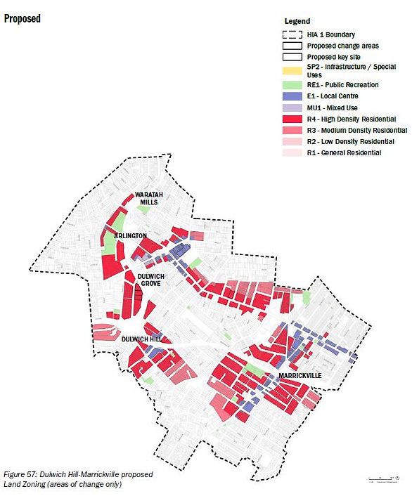
Below are the areas of change (that is being upzoned for unit blocks) in Dulwich Hill and Marrickville, and read on below for the plan pros and cons.
Plan pros and cons
Pros
There are some pros in the plan, particularly compared to the NSW Government’s Transport Oriented Development plan, including
-
Retention of most existing heritage areas
-
Avoiding dividing blocks into different zoning levels, and by doing so protecting some residents from high-density development on adjoining sites.
-
Delivering additional much-needed housing, while at the same time preserving a number of streets in the suburb for low-density development
But there is also plenty to question, as outlined below.
Cons
Development intensity and unfair spread
Under the council plans, over the next 15 years, some 21,983 new homes are earmarked for Dulwich Hill, Ashfield, Croydon and Marrickville, and 8,975 in Leichhardt, Petersham, Lewisham, Marrickville, St Peters and Sydenham.
That means, under the Council’s plans, only one suburb north of Parramatta Rd (Leichhardt) has been earmarked for increased density, and this is moderate low-rise density.
Not a single new home is proposed, under these plans, in Balmain, Rozelle, Birchgrove, Annandale or Haberfield.
Most development is concentrated in the south-west corner of the LGA, and in particular Ashfield Ward.
The elected Councillors appeared sensitive to this issue last Tuesday night, asking staff to begin working on a “second stage” of the plans for areas which were “not examined fully” in this “first stage” of plans. This so-called “second stage” was not referenced in the staff report to council.
The "second stage" would involve greater density in and around the Bays Precinct station (where 3-5,000 homes are proposed), along Parramatta Rd, and on main streets and near light rail stations (presumably outside of Dulwich Hill which has already been examined).
Lack of transparency
The plans do not state how many homes are coming to Dulwich Hill. This is needed.
How can we comment on plans when we don’t know how many homes we are getting?
Significant transition issues
Residents in several streets are facing looking across the road at 8 or 10 storey development. This seems like a very harsh transition.
Heritage removal
The heritage conservation area on the southern side of Wilga Rd is set to be removed, to allow high-rise development, for no clear reason. The homes on this side of Wilga Rd all contribute to the streetscape.
Not a single reason is given by the heritage consultant for the lifting of the heritage area, which makes this move highly suspicious.
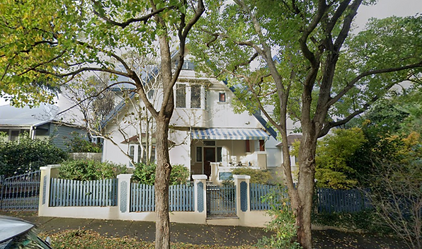
Similarly, it is proposed to remove the current heritage listing over Leonardi, a home at 61 Garnet St associated with Frederick William Broadhurst, who ran a boatshed on the property for recreational boating on the Cooks River from 1913 (photo below).
This home has a distinctive pitched roof and important social story and, given the site is not proposed for development, the proposed heritage listing removal is puzzling.
Seaview St towers
The isolated new towers on the Seaview St carpark will involve a major character change to our dynamic but intimate and human-scaled village.
One suspects the council, as the landowner, is seeking to fund the community facilities purely through development yield. As a community, we should have the right to be involved in this decision. There has been no transparency to date about council deliberations on this issue.
This development will also involve the demolition of the old Dulwich Hill School of Arts cottage (not heritage listed and currently used as a gym).
Infrastructure
The infrastructure analysis to support this growth is thin.
It’s proposed that there’s a new community hub at the Seaview St carpark site, with:
-
1,500–1,900 sq/m of hireable community spaces with a mix of small and large halls.
-
1,000 sq.m of cultural spaces with fit-for-purpose performance, community participation, and production areas.
-
700–800 sq/m of affordable spaces for not-for-profit and community service providers.
As mentioned above, it is also proposed that there is 2,000 sq/m new public plaza at the Seaview St car park development site.
There’s a ten-page strategic transport plan with some helicopter-level aspirations about improving cycling, walking and public transport.
Some incremental open space improvements are proposed, however it looks almost certain that the suburb’s provision of open space per person will fall (it’s not possible to determine this because our suburb’s dwelling target has not been released). The council report acknowledges additional sporting fields are needed, but only has a proposed solution to lobby the NSW Government to allow the council to access school fields.
There is also no analysis of the current capacity of school and health facilities to accommodate this growth.
The infrastructure situation has been further confused by an amendment moved at last Tuesday’s Council meeting which said that “the acquisition of new housing stock, owned by Council in perpetuity, be made the highest priority for public benefits to be achieved through developer contributions”. This would appear to indicate that much-needed local infrastructure - needed by existing and future residents - is a far lower priority than council-owned housing. It seems as though the only focus is housing.
What’s needed is a clear, comprehensive and exhibited infrastructure plan. The report to the Council meeting said an Inner West Infrastructure Delivery Plan will be reported to Council in late 2025, but it’s disappointing to see the lack of detail at this time.
Affordable housing
Larger developments (with a gross floor area of 2,000 sq/m or more) will only be required to provide 2% of their floor space as affordable housing. Mayor Darcy Byrne has already indicated he thinks this number should be higher.
Conclusion
It seems far more work needs to be done on the plans, to ensure they represent a fairer future for the Inner West.
It was encouraging to hear, from Inner West Mayor Darcy Byrne, that feedback is sought.
“This is not a report from Council, but a report to Council, which has been prepared by Council staff and consultants," he told the meeting.
“And I don’t think everything about this plan is perfect…but I think it is better for the community to see transparently what has been proposed, not by us, but to us, and then we can make up our minds, when we’ve read all the submissions, how it should be amended.”
We will continue to analyse the plans and are interested in what our members have to say about the plans. Please email us at savedully@hotmail.com